Rivers, the lifeblood of our planet, are constantly shaping and reshaping the landscapes they traverse. While seemingly distinct, floodplains, sandbars, and river deltas are intricately linked, each sculpted by the dynamic forces of flowing water and sediment transport.
What do floodplains, sandbars, and river deltas have in common?
Imagine a river, swollen with rainfall, surging downstream. As it overflows its banks, it spills onto the adjacent land, creating a floodplain. These flat, low-lying areas act like natural sponges, absorbing excess water and preventing catastrophic floods further downstream. As the floodwaters recede, they leave behind a gift: nutrient-rich sediment that makes floodplains incredibly fertile grounds for diverse ecosystems to flourish.
Now, picture the same river, carrying sand and pebbles as it carves its path. In areas where the current slows, these sediments settle, giving rise to temporary “islands” known as sandbars. Although transient, sandbars provide crucial habitats for fish, insects, and other aquatic life, adding to the overall biodiversity of the river system.
Finally, as the river approaches its terminus, where it meets a larger body of water like a lake or ocean, its flow dramatically slows. This decreased energy causes the river to deposit the vast quantities of sediment it has been carrying throughout its journey. Over time, this deposition creates a fan-shaped landform known as a river delta. Deltas are dynamic ecosystems, teeming with life and supporting a rich tapestry of habitats, from marshes and wetlands to forests and estuaries.
These three landforms—floodplains, sandbars, and river deltas—are more than just aesthetically pleasing features of a river system. They play vital roles in maintaining the health and equilibrium of the entire watershed. Floodplains mitigate floods, sandbars enhance habitat diversity, and deltas filter pollutants and provide nurseries for countless species.
Are Deltas and Floodplains the Same?
While both deltas and floodplains are shaped by the deposition of sediment from rivers, they are distinct landforms with unique characteristics.
Floodplains are found alongside rivers and streams, forming when a river overflows its banks and deposits sediment onto the adjacent land. These areas are flat and low-lying, subject to periodic inundation.
Deltas, on the other hand, are located at the mouth of a river, where it enters a larger body of water. As the river slows down upon entering the larger water body, it deposits its sediment load, creating a delta.
Delta plains are flat, low-lying areas surrounding the delta itself. They are exceptionally fertile due to the accumulation of nutrient-rich sediment deposited by the river.
Here’s a table that summarizes the key differences:
Feature
Description
Floodplain
The flat area next to a river that floods occasionally, depositing sediment.
Delta
A landform created at the mouth of a river where it enters a larger body of water, formed by sediment deposits.
Delta Plain
The flat, low-lying area surrounding a delta, often very fertile.
Understanding the interconnectedness of these features, and how they are affected by both natural processes and human activities, is crucial for effective river management and conservation efforts.
What soils are associated with floodplains and river deltas?
The soils found in floodplains and river deltas are directly influenced by the regular deposition of sediments carried by rivers. These soils tend to be incredibly fertile, rich in nutrients, and often boast a blend of textures.
Floodplain soils are primarily composed of alluvium, a mixture of sand, silt, and clay deposited by floodwaters. The exact composition of alluvial soils can vary depending on the river’s source, the terrain it flows through, and the velocity of the water.
River delta soils share similarities with floodplain soils, often exhibiting a blend of sand, silt, and clay. However, the presence of salt water in delta environments introduces unique characteristics. The mixing of freshwater and saltwater can create a mosaic of soil types, each with its own salinity tolerance and ability to support different plant and animal communities.
Research suggests that several factors can influence the composition and characteristics of soils in floodplains and deltas, including:
Climate change, which can alter precipitation patterns and flood frequency, potentially leading to changes in sediment deposition.
Dam construction, which can trap sediment upstream, reducing the amount of sediment reaching downstream floodplains and deltas.
Land use practices, such as deforestation and agriculture, can increase erosion rates, leading to higher sediment loads in rivers and subsequent deposition downstream.
Understanding the complex interplay between these factors is essential for managing and conserving these valuable ecosystems.
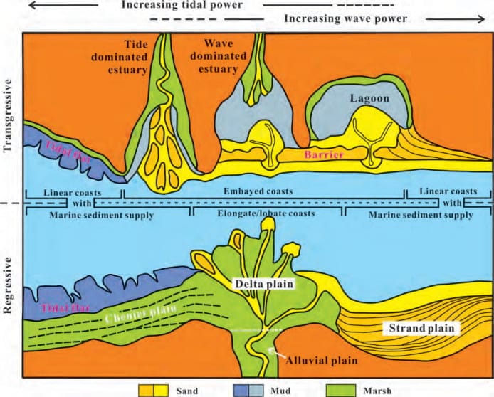
What are the 2 types of river deltas?
River deltas, those dynamic landforms at the mouths of rivers, are not created equal. They vary significantly in shape, size, and the processes that govern their formation. One key distinction lies in the type of water body the river empties into, leading to two primary types of deltas:
1. Lacustrine Deltas: The “Lake Lovers”
As the name suggests, lacustrine deltas form where rivers flow into lakes. The relatively calm and confined waters of lakes result in deltas that are typically smaller and less intricate than their coastal counterparts. Because wave action is less intense in lakes, lacustrine deltas often exhibit a more symmetrical, fan-shaped morphology.
2. Coastal Deltas: The “Ocean Goers”
Coastal deltas, in contrast to their lacustrine cousins, form where rivers meet the vast expanse of oceans or seas. These deltas are shaped by a more complex interplay of forces, including river discharge, wave action, tides, and coastal currents. The dynamic nature of these environments often leads to the formation of large and intricate deltas, characterized by branching channels, extensive wetlands, and a greater variety of habitats.
The Mississippi River Delta, emptying into the Gulf of Mexico, is a prime example of a vast and intricate coastal delta.
What is a delta as it relates to rivers?
Imagine a river, its journey nearing its end as it approaches a larger body of water. Laden with sediments—sand, silt, and clay—eroded and carried from upstream, the river’s velocity slows as it enters this larger water body.
This decrease in velocity causes the river to lose its ability to transport the accumulated sediments, leading to their deposition at the river’s mouth. Over time, this deposition creates a unique landform known as a delta. Essentially, a delta is a landmass built by a river’s sediment deposits.
Deltas are more than just sediment dumps; they are dynamic and ecologically important ecosystems. The constant interplay of freshwater from the river and saltwater from the sea creates a unique environment that supports a wide array of plants and animals. Deltas act as natural filters, trapping pollutants and excess nutrients before they reach the open water. They also serve as critical nurseries for many fish and shellfish species, contributing significantly to the productivity of coastal fisheries.
The shape and size of a delta depend on several factors, including the volume of sediment carried by the river, the strength of ocean currents and tides, and the topography of the surrounding coastline. Some deltas, like the Nile River Delta, are densely populated and agriculturally important, while others, like the Amazon River Delta, are home to vast and biodiverse rainforests.
What do floodplains, sandbars, and river deltas have in common?
Floodplains, sandbars, and river deltas, while distinct landforms, share a fundamental connection: they are all created by the dynamic interplay of water flow and sediment transport within a river system.
Erosion, Transportation, and Deposition:
Rivers are masters of erosion, carving through rock and soil as they flow downstream. This eroded material, called sediment, is transported by the river, sometimes for hundreds or even thousands of miles. When the river’s velocity decreases, it loses its ability to carry this sediment, resulting in deposition.
Floodplains form when a river overflows its banks, spreading sediment-laden water onto the adjacent land. Over time, these deposits build up, creating a flat, fertile plain.
Sandbars are temporary features that form within the river channel itself. As the river flows, it carries sand and gravel downstream. In areas where the current slows, these heavier particles settle out, forming a sandbar.
River deltas are the grand finale of sediment deposition. As a river enters a larger body of water, its velocity dramatically decreases, causing it to deposit the vast majority of its sediment load, forming a delta.
Ecological Importance:
All three landforms – floodplains, sandbars, and deltas – play crucial roles in the ecological health of river systems and surrounding landscapes. They provide essential habitats for a diverse array of plants and animals, filter pollutants, mitigate floods, and contribute to the overall productivity of ecosystems.
What is the difference between delta and plains?
While both deltas and plains are relatively flat landforms, their formation processes and characteristics differ significantly.
Deltas:
Formation: Created by the deposition of sediment at the mouth of a river as it enters a larger body of water (ocean, lake, or another river).
Shape: Typically fan-shaped or triangular, with distributary channels branching out from the main river channel.
Elevation: Generally low-lying and prone to flooding, as they are actively being built by sediment deposition.
Soil: Fertile due to the constant deposition of nutrient-rich sediment.
Examples: Nile River Delta, Mississippi River Delta, Ganges-Brahmaputra Delta.
Plains:
Formation: Can be formed by a variety of processes, including erosion, deposition, and tectonic uplift.
Shape: Generally flat and expansive, with few significant changes in elevation.
Elevation: Can vary, with some plains located at high elevations.
Soil: Can vary widely in fertility depending on the underlying geology and formation processes.
Examples: Great Plains of North America, Indo-Gangetic Plain, Siberian Plains.
In essence, deltas are formed specifically by riverine processes and are characterized by their association with river mouths and sediment deposition. Plains, on the other hand, encompass a broader category of flat landforms with diverse origins and characteristics.
What landforms are called deltas?
The term “delta” specifically refers to a type of landform created at the mouth of a river where it enters a larger body of water, such as an ocean, lake, or another river. Deltas are formed by the deposition of sediment carried by the river as it slows down upon entering the larger water body. Key characteristics of deltas include:
Shape: Typically fan-shaped or triangular, resembling the Greek letter delta (Δ).
Distributaries: Branched channels that distribute water and sediment across the delta.
Sediment Deposition: Characterized by the accumulation of sand, silt, and clay, creating fertile soils.
Dynamic Environments: Constantly evolving due to ongoing sediment deposition, erosion, and the influence of tides and currents.
Examples of well-known deltas around the world include:
Nile River Delta (Egypt): One of the largest and most fertile deltas, supporting a vast agricultural region.
Mississippi River Delta (United States): A complex delta system emptying into the Gulf of Mexico, facing challenges from subsidence and sea-level rise.
Ganges-Brahmaputra Delta (Bangladesh and India): The world’s largest delta, home to a dense population and vulnerable to flooding.
Mekong River Delta (Vietnam): A vast and fertile delta, crucial for rice production and aquaculture.
What is the difference between delta and levees?
While both deltas and levees are found in riverine environments and involve the deposition of sediment, they serve different functions and have distinct characteristics.
Delta:
Definition: A landform created at the mouth of a river where it enters a larger body of water, formed by the deposition of sediment as the river slows down.
Formation: Created by the gradual accumulation of sediment over time.
Function: Acts as a transition zone between a river and a larger body of water, dispersing the river’s flow and creating a unique habitat.
Levee:
Definition: A natural or artificial embankment along a river, lake, or canal that regulates water levels.
Formation: Natural levees are formed by the deposition of sediment along the riverbanks during floods. Artificial levees are constructed to prevent flooding.
Function: Primarily serves to confine the flow of water and prevent flooding of adjacent areas.
Here’s a table summarizing the key differences:
Feature
Delta
Levee
Location
River mouth
Along riverbanks
Formation
Sediment deposition
Sediment deposition (natural) or construction (artificial)
Function
Transition zone, habitat creation
Flood control
In essence, deltas are landforms created by sediment deposition at river mouths, while levees are embankments that regulate water levels and protect against flooding along the river’s course.
What is called the delta of a river?
The term “delta,” in geographical terms, specifically refers to the landform created at the mouth of a river where it enters a larger body of water like a lake, ocean, or another river. It’s essentially a depositional area, formed over time by the accumulation of sediment – sand, silt, clay – carried by the river.
Think of a river as a conveyor belt, transporting sediment downstream. As it approaches its outlet, its velocity decreases. This loss of energy causes the river to deposit its sediment load, which gradually builds up and spreads outwards, often in a fan shape, resembling the Greek letter delta (Δ).
Deltas are dynamic environments, constantly changing due to the ongoing interplay of sediment deposition, river flow, tides, waves, and other coastal processes. They are incredibly important ecologically, serving as:
Biodiversity hotspots: The mix of freshwater and saltwater creates a unique habitat that supports a wide range of plant and animal species.
Natural filters: Deltas trap pollutants and excess nutrients, improving water quality downstream.
Coastal protection: They buffer the coastline from erosion and storm surges.
What is a floodplain called a floodplain?
The term “floodplain” is a rather literal and self-explanatory term in geography. It refers to the flat, low-lying area adjacent to a river or stream that is prone to periodic flooding.
Floodplain Formation:
Imagine a river, carrying sediment downstream. During periods of heavy rainfall or snowmelt, the river’s volume increases. If this increased volume exceeds the capacity of the river channel, water spills over the banks and onto the surrounding land. This overflowing water, laden with sediment, deposits its load onto the adjacent land, gradually building up over time to create a floodplain.
Why “Floodplain”?
The term accurately reflects the primary characteristic of this landform: its susceptibility to flooding. Floodplains are, by their very nature, areas that experience periodic inundation by river water.
Importance of Floodplains:
Floodplains, while seemingly inconvenient due to their flood risk, are ecologically and hydrologically vital:
Flood Mitigation: They act like natural sponges, absorbing excess floodwater and reducing the risk of downstream flooding.
Nutrient Cycling: Floodwaters deposit nutrient-rich sediments onto the floodplain, enriching the soil and supporting productive ecosystems.
Habitat Diversity: Floodplains create a mosaic of habitats, from wetlands to forests, supporting a wide array of plant and animal species.
Despite their importance, floodplains are often threatened by human development, which can alter natural flooding patterns and degrade these valuable ecosystems.
Key Points:
Floodplains, sandbars, and river deltas are all shaped by the flow of water.
Floodplains are low-lying areas near rivers that receive sediment deposits from floods.
Sandbars are temporary “islands” formed by sand and pebbles settling in areas of slower water flow.
River deltas are fan-shaped areas created at river mouths where sediment is deposited as the river slows down.
These formations are vital to healthy ecosystems:
Floodplains absorb floodwaters and filter pollutants.
Sandbars provide crucial habitats for aquatic life.
Deltas support a diverse mix of plants and animals.
Climate change poses challenges to river systems, impacting these interconnected features.
Understanding these formations is crucial for protecting rivers and the ecosystems they support.
Key Lines:
Floodplains, delta plains, and deltas are interconnected fluvial-influenced systems that exhibit unique characteristics and dynamics.
Satellite imaging provides a comprehensive approach to studying floods and their impact on floodplains and delta plains.
Evaluating the potential for flooding and avulsion using satellite data is crucial for mitigating the risks associated with these events.
Human activities have significantly altered the shapes and processes of deltaic systems, raising concerns about their resilience and sustainability.
Hello, My love for writing is rivaled only by my passion for in-depth research. While many may skim the surface, I dive deep, seeking the hidden gems of information that give a story texture and depth. Every word I write is backed by hours of exploration, ensuring that my work is not just compelling, but also meticulously accurate. Join me on a journey where every piece is a deep dive into the realms of knowledge and storytelling.