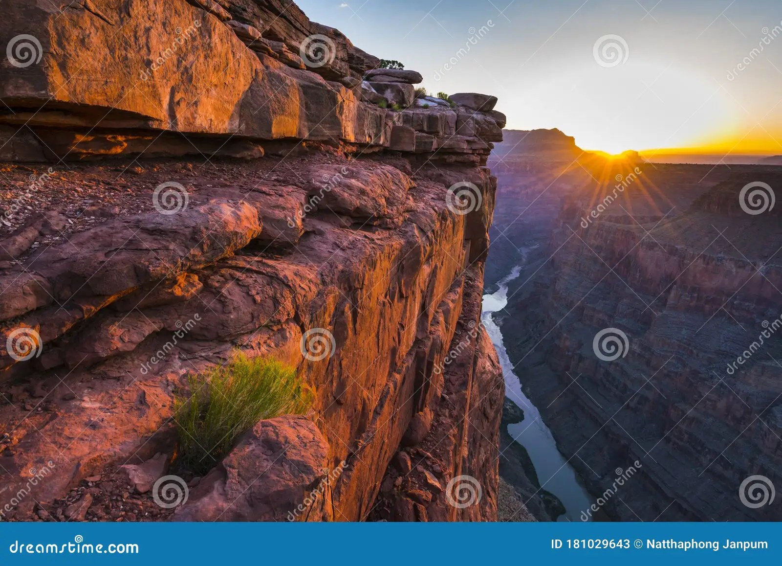
Toroweap Overlook: Ready for a Grand Canyon adventure that’s off the beaten path? Think less paved roads and railings, and more raw, jaw-dropping views. We’re talking about Toroweap – a spot where the Grand Canyon plunges a dizzying 3,000 feet down to the Colorado River. It’s not your average tourist stop. Getting there means bouncing down a pretty rough dirt road, but trust us, the view is worth it. If you’re looking for peace, quiet, and some seriously amazing scenery (we’re talking 8-million-year-old lava flows!), Toroweap is calling your name. Let’s get you prepped for this incredible journey.
Planning Your Toroweap Adventure
So, you’re thinking about visiting Toroweap Overlook in 2024? Excellent choice! This guide will help you prepare for a safe and unforgettable trip to this truly special, remote spot in Grand Canyon National Park.
Getting There: Embark on the Journey
Reaching Toroweap is an adventure in itself. Located on the North Rim, it requires navigating the 61-mile Mohave County Road 109, a rugged dirt road south of Fredonia, Arizona. A high-clearance, four-wheel-drive vehicle is absolutely essential – no two ways about it. Alternative routes, like Clay Hole Road, exist, but present similar challenges. To put the remoteness in perspective, it’s a 148-mile drive from North Rim Headquarters, while a raven could likely cover the distance in a mere 55 miles!
Essential Preparations: Permits, Weather, and Supplies
Before you go, thorough planning is crucial. Check the National Park Service website for any permit or reservation requirements. Weather at Toroweap can be extreme, ranging from scorching summers with intense monsoons to icy winters. Early morning travel can help mitigate the dangers of summer flash floods. Pack accordingly, with ample water, food, and emergency supplies. Cell service is likely nonexistent, so download offline maps and inform someone of your itinerary.
A Geological Masterpiece: Unveiling Toroweap’s Wonders
Imagine standing on the rim, gazing 3,000 feet down at the Colorado River carving its way through the canyon. This is Toroweap. Eight-million-year-old lava flows paint the landscape, evidence of Earth’s volcanic past. This unique vantage point is thanks to the Esplanade Platform—a geological formation created by the erosion of Hermit Shale layered over more resistant Esplanade Sandstone. It’s a giant, open-air geology museum.
Experiencing Toroweap: Hiking, Photography, and Solitude
Hiking is a must at Toroweap. Explore the trails and connect with this incredible landscape. Photographers, like Jim Zuckerman, have captured breathtaking images here. Consider the light, shadows, and the canyon’s scale – it’s a photographer’s paradise. But the best activity might be simply breathing and soaking in the solitude. Unlike the bustling South Rim, Toroweap offers tranquility and a true connection with the Grand Canyon’s raw beauty. Don’t forget to check out other points of interest during your trip, perhaps even exploring the history of the USS Hobson Memorial or the vibrant underwater world of the USS Spiegel Grove.
Toroweap vs. the South Rim: A Contrast in Experiences
If you’ve visited the South Rim, prepare for a vastly different experience at Toroweap. It’s a sanctuary from the crowds, a place to lose yourself in the canyon’s vastness and appreciate its wild heart.
Essential Information at a Glance
| Feature | Details |
|---|---|
| Location | North Rim of Grand Canyon National Park, Arizona. 61 miles south of Fredonia via Mohave County Road 109. |
| Distance from HQ | 148 miles by road (a long haul!), but only 55 miles as the crow flies. |
| Elevation | Around 4,552 feet above sea level, with a 3,000-foot drop to the river. |
| Road Conditions | Unpaved, rough, requiring a high-clearance 4×4 vehicle. Conditions can vary significantly due to weather (muddy in winter, potentially flooded during summer monsoons). |
| Weather | Extreme conditions, from scorching summer heat to freezing winters. Summer monsoons (July-September) can be intense. Always check the NPS website for current conditions. |
| Geology | Witness 8-million-year-old lava flows and the Esplanade Platform, formed by eroded Hermit Shale over Esplanade Sandstone. |
| Activities | Hiking, photography, and simply absorbing the awe-inspiring views. |
Tuweep: Another Name, Same Amazing Place
You might also hear this area called “Tuweep,” a Paiute word meaning “the earth.” It captures the deep connection you feel with this natural wonder. Toroweap Overlook isn’t just a viewpoint; it’s an experience. Plan well, be prepared, and get ready for an unforgettable adventure.
What is the Best Road to Toroweap Overlook?
Dreaming of that epic Grand Canyon adventure? You want Toroweap Overlook. But first, you need to figure out how to get there. Let’s talk roads.
The Sunshine Route (CR 109): Your Most Reliable Path
Most people will point you towards the Sunshine Route (County Road 109), starting near Fredonia, Arizona. The first part is paved, but the last 3-6 miles are rugged and demand a high-clearance, four-wheel-drive vehicle.
Beyond the Sunshine: Exploring Alternative Routes
For adventurous spirits, less-traveled paths exist. However, these are often less maintained and more challenging, requiring an experienced driver and a well-equipped 4×4 vehicle.
Navigating the Road Less Traveled: Tips for a Smooth(ish) Journey
| Route | Road Conditions | Vehicle Requirements | Distance from Fredonia |
|---|---|---|---|
| CR 109 (Sunshine Route) | Mostly maintained pavement, last 3-6 miles very rough | High-clearance 4×4 absolutely essential | 61 miles |
| Alternative Routes | Generally less maintained, often very challenging | High-clearance 4×4 and experienced driver highly recommended | Varies, often longer |
Regardless of your chosen route, preparation is key. Cell service is unreliable, so inform someone of your plans. Pack water, snacks, and emergency supplies. Ensure your vehicle is in top condition, with a full tank of gas and a reliable spare tire.
Once you crest that final rise, you’ll be rewarded with the breathtaking view of Toroweap Overlook—a 3,000-foot vertical drop to the Colorado River. Enjoy the grandeur and silence. You’ve earned it.
Can you See the Colorado River from the North Rim?
Wondering about the best views of the Colorado River from the North Rim? The answer is yes, but with some important considerations.
Toroweap Overlook: A Premier Viewing Spot
Toroweap Overlook offers perhaps the most dramatic view of the Colorado River from the North Rim. Imagine standing on a sheer cliff, gazing down at the emerald ribbon of the river 3,000 feet below. It’s a visceral connection to the canyon’s power.
The Journey to Toroweap: An Adventure Itself
Reaching this isolated overlook requires navigating a rough, unpaved 60-mile road. A high-clearance, four-wheel-drive vehicle is highly recommended, especially if rain is a possibility.
Exploring Other North Rim Vistas
While Toroweap offers the most direct river view, other viewpoints like Point Imperial, Cape Royal, and Bright Angel Point offer breathtaking panoramic vistas. These may not offer the same intimate view of the river, but they present the canyon’s vastness in a different light.
Hiking to the River: A Challenging Option
Hiking to the river from the North Rim is possible but requires careful planning, permits, and extensive backcountry experience. Contact Grand Canyon National Park Service for details.
Planning Your North Rim Adventure: Essential Tips
Thorough planning is crucial. Check road conditions, especially for Toroweap. Inform someone of your itinerary, pack ample water, download offline maps, and be prepared to unplug.
What is the Elevation of Toroweap?
Toroweap Overlook is more than a viewpoint; it’s an experience. Let’s explore the practicalities, like its elevation and what to expect.
The elevation of Toroweap Overlook is approximately 4,552 feet above sea level (some sources suggest 4,540 feet). This elevation contributes significantly to the dramatic views. Be aware that changes in elevation can affect individuals differently.
Getting to Toroweap involves a 61-mile off-road adventure, requiring a high-clearance vehicle. Expect rugged, unpaved roads that test both your driving skills and your vehicle’s capabilities. The reward is unparalleled: solitude and breathtaking views.
From the overlook, you’ll witness a 3,000-foot vertical drop to the Colorado River. It’s an overwhelming sense of nature’s vastness and power.
Prepare for a remote wilderness experience. There are no amenities at Toroweap. Self-sufficiency is essential. Pack ample water, food, emergency supplies, and offline maps. Weather conditions can change dramatically, so check with the National Park Service before you go and inform someone about your plans.
Toroweap is also a geological wonderland. Observe the layers of rock: Hermit Shale, Esplanade Sandstone, and evidence of volcanic activity from the Uinkaret volcanic field. It’s a fascinating glimpse into Earth’s history.
“Tuweep,” a Paiute word meaning “the earth,” refers to the wider area. “Toroweap,” meaning “dry or barren valley,” describes the valley and overlook. While the National Park Service uses “Tuweep,” understanding this distinction adds a deeper cultural appreciation.
| Feature | Details |
|---|---|
| Elevation | Approximately 4,552 feet (some sources say 4,540 feet) |
| Road Conditions | 61 miles of unpaved, rugged road; high-clearance vehicle required |
| Amenities | None; self-sufficiency is essential |
| Key Features | 3,000-foot drop to the Colorado River, unique geological formations |
| Name Variation | “Tuweep” (broader area), “Toroweap” (specific valley/overlook) |
Visiting Toroweap requires planning and preparation, but the experience is truly rewarding. Respect the environment, prioritize safety, and embrace the adventure.
- Discover Long Black Pepper: Flavor & Health Benefits - April 25, 2025
- Shocking Twists: The Grownup Review: Unreliable Narration - April 25, 2025
- A Quiet Place Book vs Movie: A Deep Dive - April 25, 2025


