Imagine going on an adventure to discover Earth’s amazing history, like a treasure hunt where the clues are hidden in rocks! These rocks, called sedimentary rocks, are like a big scrapbook or diary of our planet. They tell us about the past climate, landscapes, and even the creatures that lived long ago. So, let’s embark on this journey to uncover the secrets buried within these rocky pages!
Sedimentary Facies and Sequences: Unlocking Earth’s Secrets
Unveiling the story of Earth’s past is like assembling a giant puzzle, and every piece of the puzzle is a sedimentary rock. These rocks, like time capsules, hold within them clues about the environments in which they formed: the water’s depth, the energy levels, and the creatures that roamed the Earth.
Sedimentary Facies: Fossils of Ancient Environments
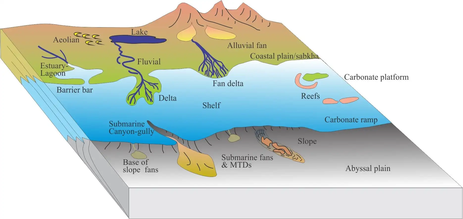
Imagine each sedimentary rock as a snapshot of a particular time and place. The physical, chemical, and biological characteristics of each layer, called a facies, tell a story about the environment that existed when that layer was formed. For example, a layer with coarse sand and ripple marks suggests a beach environment, while a layer with fine mud and plant fossils might indicate a quiet lagoon.
Sequences: Layers of Earth’s History
Just as layers of cake tell a story about how the cake was baked, sedimentary rock sequences reveal how Earth’s environments have changed over time. Each layer represents a different chapter in the planet’s history, from the formation of mountains to the shifting of oceans. Studying these sequences helps us piece together the puzzle of how our planet evolved.
Relevance to Understanding Earth’s Story
Unlocking the secrets of sedimentary facies and sequences helps us not only understand Earth’s past but also its present and future. It helps us predict where natural resources, like oil and gas, might be found. It also sheds light on how geological structures, like mountains and valleys, were formed. In a way, these rocks are like ancient scrolls, revealing the tale of Earth’s incredible journey.
Lagoon Facies: Fine mud, plant fossils, calm waters
Delta Facies: Interbedded sand and mud, organic matter
Canyon Sequence: Alternating layers of coarse and fine sediments, cut by a deep channel
Transgressive Sequence: Gradual upward change from marine to non-marine sediments
The Power of Technology
Today, scientists use advanced technology, like seismic sedimentology, to analyze sedimentary facies and sequences. Seismic data, like ripples in a pond, allows us to see deep into the Earth and understand the structure and composition of these rock layers.
By deciphering the language of sedimentary facies and sequences, we unlock the secrets of Earth’s history and gain a deeper appreciation for our planet’s incredible journey.
How can sequence stratigraphy be used to predict the location of oil and gas deposits?
If you’re in the oil and gas exploration business, you need to know about sequence stratigraphy. Why? Because it helps you predict where the good stuff is hiding! Here’s how it works:
Digging into Earth’s History
Sequence stratigraphy is like reading layers of an old scrapbook, telling the story of how the Earth’s surface has changed over time. By studying these layers of rock and sediment, geologists can uncover past environments and how they’ve shifted over millions of years.
Finding the Treasure Troves
The reason this matters so much is that the best places to find oil and gas are often tucked away within specific sections of this geological scrapbook. These treasure troves are called reservoirs, and they’re formed when the conditions were just right for hydrocarbons to form and get trapped.
Spotting the Signs
Geologists use sequence stratigraphy to identify these reservoirs by looking for particular patterns in the layers of rock. For example, they look for signs of changes in sea level, which can create different types of depositional environments. These environments, like river deltas and deep-sea basins, are often associated with different types of reservoirs.
Making the Predictions
Once geologists have identified the likely reservoirs, they can predict where the oil and gas are most likely to be found. It’s like solving a puzzle, where each piece of information brings you closer to the hidden treasure.
Step-by-Step Guide to Sequence Stratigraphy
Observe and Analyze: Start by examining the rock layers and identifying any patterns or variations.
Identify Boundaries: Trace the boundaries between different depositional units to create a sequence of events.
Interpret Environments: Determine the environmental conditions associated with each unit, such as sea level changes or river systems.
Locate Reservoirs: Map out the areas where reservoir-forming conditions occurred, like high-energy channel deposits or deep-sea basins.
Predict Hydrocarbon Presence: Based on the identified reservoir characteristics, geologists can predict the likelihood of finding oil or gas.
Why it’s a Big Deal
Sequence stratigraphy is a vital tool for geologists because it helps them target their exploration efforts and increase the chances of finding oil and gas deposits. By understanding the geological history of an area, they can make educated guesses about where to drill and potentially strike gold!
What is Multi-Attribute Facies Analysis and How Can It Amplify Our Interpretation of Sedimentary Environments?
Picture this: You’re a detective, digging into a perplexing crime scene. You don’t rely solely on a single fingerprint or footprint; you gather all the clues you can find – fibers, tire tracks, DNA. Well, geologists use a similar approach when decoding sedimentary environments. And that’s where multi-attribute facies analysis (MAFA) shines.
MAFA is a geological superpower that combines multiple seismic attributes – like the amplitude of a sound wave, its frequency, and how it bounces off different rocks – into a single, comprehensive analysis. It’s like a detective with a dozen different magnifying glasses, able to see details that would slip through the cracks otherwise.
This blend of attributes gives geologists a more accurate and detailed picture of the ancient world hidden beneath our feet. MAFA illuminates the different types of sediment, how they were deposited, and the processes that shaped them. It’s like going from a blurry snapshot to a high-resolution photograph.
Benefits of MAFA:
Crystal-Clear Clarity: MAFA provides sharper insights into sedimentary environments, surpassing traditional methods.
Effortless Automation: Machine learning algorithms do the heavy lifting, automating the process and reducing biases.
Hidden Depths Unveiled: MAFA uncovers hidden geological stories, making it invaluable for reservoir characterization and exploration.
Key Points to Remember:
MAFA combines multiple seismic attributes to decode sedimentary environments.
It uses machine learning to simplify complex analysis.
MAFA unlocks geological secrets and boosts exploration efficiency.
How do sedimentary facies transitions reflect changes in depositional processes?
Understanding the history of our Earth is like piecing together a giant jigsaw puzzle. Geologists do this in part by studying sedimentary rocks, which are like time capsules that hold clues to the past.
Sedimentary rocks form when sediment, like sand and mud, settles to the bottom of bodies of water like rivers, lakes, or oceans. Just like each room in your house has a different purpose, each type of water body creates a unique signature in the rocks it forms.
Imagine a cozy living room with a fluffy rug and soft lighting. That’s like a slow-moving lake. The fine particles settle gently and form a calm, layered look.
Now picture a busy kitchen with pots and pans clanging away. That’s like a roaring river. The rough grains get tossed around like salad, creating a coarse and bumpy texture.
When the water body changes, like when a river slows down to become a lake or a lake swells into an ocean, the sediment it deposits changes too. These changes are called “facies transitions.”
They can be like a gradual fade from one room to another or a sudden jump. A gradual transition might look like the living room rug getting a bit coarser, while a sudden transition would be like the kitchen suddenly transforming into a swimming pool.
By reading these “sedimentary diaries,” geologists can piece together ancient environments and their changes. It’s like deciphering the secret code of our Earth’s history.
FAQ
Q1: What are sedimentary facies and how can they help us understand past environments?
A1: Sedimentary facies are physical, chemical, and biological characteristics of a sedimentary rock that can change laterally over time. By studying sedimentary facies, geologists can infer the depositional environment in which the sediment was deposited, such as a river, beach, or deep-sea fan.
Q2: What is sequence stratigraphy and how is it used to interpret the geologic history of sedimentary basins?
A2: Sequence stratigraphy is a framework for analyzing sedimentary sequences that considers both the vertical and lateral relationships between facies. By identifying and correlating key surfaces within a sedimentary sequence, geologists can reconstruct the history of deposition, erosion, and sea-level change that occurred in a basin.
Q3: How can seismic data be used to interpret sedimentary facies and architecture?
A3: Seismic data can be used to create images of the subsurface, which can be interpreted to identify different types of sedimentary facies and their spatial relationships. This information can help geologists to understand the depositional environment and the geologic history of an area.
Q4: What are some of the applications of facies analysis and sequence stratigraphy in the oil and gas industry?
A4: Facies analysis and sequence stratigraphy are used in the oil and gas industry to identify potential hydrocarbon reservoirs and to predict the distribution of oil and gas within a reservoir. By understanding the depositional environment and the geologic history of an area, geologists can better predict where hydrocarbons are likely to be found.
Q5: How are sedimentary facies and sequences used to study climate change and other environmental issues?
A5: Sedimentary facies and sequences can be used to study climate change and other environmental issues by providing a record of past environmental conditions. For example, by studying the sedimentary facies of ancient reefs, geologists can learn about changes in sea level and temperature over time. This information can help us to understand how the climate has changed in the past and how it may change in the future.
Hello, My love for writing is rivaled only by my passion for in-depth research. While many may skim the surface, I dive deep, seeking the hidden gems of information that give a story texture and depth. Every word I write is backed by hours of exploration, ensuring that my work is not just compelling, but also meticulously accurate. Join me on a journey where every piece is a deep dive into the realms of knowledge and storytelling.