Experience the San Andreas Fault firsthand in San Luis Obispo County, from aerial views revealing its vastness to ground-level explorations of its unique geological formations. San Luis Obispo County isn’t just near the San Andreas Fault; it’s interwoven with it, shaping the landscape and posing a constant reminder of nature’s power.
The San Andreas Up Close
The San Andreas Fault slices through San Luis Obispo County, a dramatic gash in the Earth’s crust, showcasing the immense power of nature. This isn’t merely a crack; it’s a window into the geological forces that have molded California’s landscape. Exploring this area provides a firsthand encounter with our planet’s raw energy and a chance to delve into the science of earthquakes.
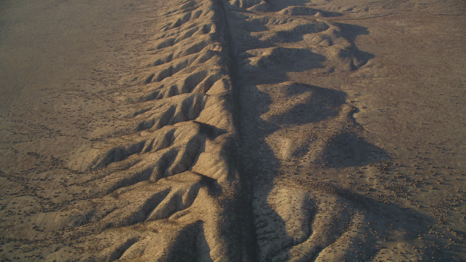
One of the best ways to grasp the fault’s scale is from the air. An aerial tour offers a bird’s-eye view, revealing its reach and intricate fractures—a giant scar across the land. This perspective highlights the complex patterns created by eons of tectonic plate movement. Drone footage, readily available online (often from local news sources like the San Luis Obispo Tribune), offers a similar perspective.
Back on the ground, Wallace Creek vividly demonstrates the fault’s relentless creep. Here, the creek bed is dramatically offset, a visual testament to the slow but powerful forces at play. Imagine a stream jolted sideways over time—a striking example of how seemingly small movements accumulate into significant changes.
For a deeper dive into earthquake science, Parkfield, the self-proclaimed “Earthquake Capital of the World,” is a must-see. Bristling with scientific instruments monitoring the fault’s every quiver, researchers here constantly gather data, hoping to unlock the secrets of earthquake prediction. While predicting earthquakes with absolute certainty remains elusive, Parkfield’s ongoing research provides invaluable insights into the fault’s behavior and the complex processes that trigger seismic activity. You can even learn more about one of their recent digs here.
San Luis Obispo and the Fault Line
San Luis Obispo isn’t just near a fault line; it’s practically on top of it—the San Andreas Fault, to be precise. This 800-mile fracture, stretching from Southern to Northern California, is a major player in the state’s seismic activity. It’s a strike-slip fault, meaning the land on either side moves horizontally, not vertically. San Luis Obispo straddles this geological giant, placing it squarely in earthquake territory.
The Carrizo Plain, a vast valley also in San Luis Obispo County, offers a dramatic visualization of the fault. Here, the stark, straight line of the fault is clearly visible—a powerful reminder of the forces beneath our feet. You can see the land’s shifts over time, evidence of the constant, subtle movements along the fault line. Some researchers even suggest that ground deformation patterns here might offer clues about future seismic activity.
Living in San Luis Obispo County means living with earthquakes. While we can’t prevent them, understanding the risks and preparing for them is crucial. Having an emergency plan, assembling an emergency kit, reinforcing your home, knowing how to shut off utilities, and practicing earthquake drills are all important steps. More information on earthquake preparedness can be found here.
Cities in the Quake Zone
The San Andreas Fault doesn’t just affect cities directly on top of it. Like ripples in a pond, the impact of a major earthquake would spread far and wide. The type of ground beneath a city, its proximity to other faults, and even the types of buildings present play a role in determining the extent of the damage.
The San Andreas is often divided into three segments:
Northern Segment: Cities like San Francisco, Oakland, Berkeley, San Jose, and even Santa Rosa could experience severe shaking.
Central Segment: Coastal communities like San Luis Obispo, Santa Barbara, and Ventura face risks from shaking, landslides, and potential tsunamis.
Southern Segment: The sprawling metropolis of Los Angeles, along with San Bernardino and Riverside, are particularly vulnerable in this segment.
While these cities are at higher risk, a large earthquake’s impact could extend much further, potentially disrupting infrastructure across a wide region. Ongoing research, including studies of ground motion amplification (where softer soils intensify shaking), continuously refines our understanding of these risks. New technologies for monitoring the fault and improving early warning systems offer hope for better preparation and response.
Where to See the Fault in SLO County
Want to see the San Andreas Fault up close in San Luis Obispo County? Carrizo Plain National Monument is the prime location. This vast plain, bisected by the stark line of the fault, offers a powerful encounter with a force of nature that has shaped the landscape for millennia. Look for offset fences and roads—subtle but impactful signs of the Earth’s constant movement.
Within Carrizo Plain, Wallace Creek provides a unique experience. The fault’s movement has offset the creek bed, allowing you to stand with one foot on the Pacific Plate and the other on the North American Plate. Scientists constantly monitor this area using GPS and satellite imagery, adding to our understanding of the fault’s dynamics.
While Carrizo Plain offers the most dramatic views, other areas in SLO County might reveal secondary faulting—smaller cracks branching off from the main fault. Identifying these features can be challenging, and ongoing geological surveys continue to refine our knowledge.
For a deeper understanding, consider visiting the Saltville Virginia area, which offers a different perspective on geological formations. Remember, the study of geology is an ongoing process. While we can observe the fault’s current state and infer its history, predicting its future behavior remains a complex scientific challenge.
- Revolution Space: Disruptive Ion Propulsion Transforming Satellites - April 24, 2025
- Race Through Space: Fun Family Game for Kids - April 24, 2025
- Unlocking the Universe: reading about stars 6th grade Guide - April 24, 2025
