Diving into Biomes: A Colorful Journey Across North America
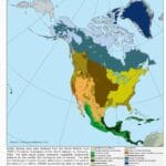
Ready to explore the vast landscapes of North America? Grab your colored pencils and a North America biome map, because we’re about to embark on a vibrant journey through the continent’s diverse ecosystems. Imagine a map painted not with states and countries, but with the very essence of nature itself – that’s the magic of a biome map!
[https://www.lolaapp.com/color-of-the-north-american-biomes]
What Exactly is a Biome?
Before we dive in, let’s define our terms. A biome is like a giant neighborhood with its own unique personality, shaped by climate, plants, and animals. Think scorching deserts, lush forests, windswept grasslands – each teeming with life uniquely adapted to those conditions.
North America: A Tapestry of Biomes
North America boasts an incredible variety of biomes, each a crucial piece in the continent’s ecological puzzle. Let’s take a glimpse at some of these diverse landscapes:
- Tundra: This frozen realm at the top of the continent is characterized by permafrost, short growing seasons, and resilient vegetation like mosses and lichens.
- Boreal Forest (Taiga): Just south of the tundra lies a vast expanse of coniferous trees – think towering pines, spruce, and fir. This biome is well-equipped for cold, snowy winters and short, cool summers.
- Temperate Deciduous Forest: Known for its stunning seasonal changes, this biome showcases broad-leaved trees that burst into fiery hues of red, orange, and yellow before shedding their leaves in the fall.
- Grassland: Imagine endless plains with fertile soil, where grasses sway in the wind and grazing animals roam freely.
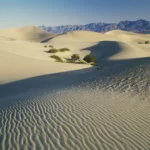
- Desert: A land of extremes, the desert is characterized by low rainfall, scorching temperatures, and specialized plants and animals that have adapted to thrive in this arid environment.
Why Biome Maps Matter: Visualizing Ecological Connections
Biome maps aren’t just colorful pictures; they’re powerful tools for understanding the intricate web of life on Earth. Here’s why they’re so important:
- Visual Learning: Biome maps translate complex ecological relationships into an easily digestible visual format, making it easier to grasp the big picture.
- Spatial Understanding: They help us visualize the geographic distribution of different biomes across North America, showing how ecosystems are interconnected across vast distances.
- Educational Powerhouse: Coloring biome maps with answer keys transforms learning into an engaging adventure for students of all ages.
Unlocking the Secrets: How Coloring Maps Enhance Your Understanding
Imagine transforming a regular map into a vibrant tapestry of colors, each shade representing a unique biome. This hands-on activity takes what might seem like dry geography and brings it to life. As you color, you begin to see patterns emerge – how biomes transition, the influence of geography, and the delicate balance within these natural communities.
Some experts suggest that this active learning approach, combining visual and tactile elements, can actually enhance information retention. Instead of passively absorbing information, you’re actively engaging with the material, making connections, and solidifying your understanding of North America’s diverse ecosystems.
Beyond the Crayons: Using Biome Maps for Conservation and Beyond
Biome maps are more than just educational tools; they’re invaluable resources for conservationists and scientists working to protect our planet. These maps act like giant ecological puzzles, with each biome a vital piece. By studying these pieces – the plants, animals, climate, and interconnectedness of each zone – we gain a clearer picture of how to best protect these vital ecosystems.
And the best part? You don’t have to be a scientist to make a difference. Citizen science projects often rely on data collected by everyday people like you. Imagine hiking through a forest, recording bird sightings, and contributing to a vast database that helps scientists monitor the health of that biome – your observations could be crucial.
Interactive Exploration: Taking Biome Learning Digital
Get ready to take your exploration to the next level with interactive digital biome maps. These dynamic tools allow you to zoom in on specific regions, uncover layers of information, and even test your knowledge with interactive quizzes. It’s like having a virtual field trip at your fingertips!
The Future of Biome Maps: A World of Possibilities
As technology advances and our understanding of the natural world deepens, who knows what exciting features future biome maps might hold? Imagine virtual reality experiences where you can step inside different biomes, or augmented reality apps that overlay ecological information onto your real-world surroundings.
The possibilities are endless, but one thing remains clear: biome maps, in all their forms, will continue to be powerful tools for education, conservation, and fostering a deeper appreciation for the incredible diversity of life on Earth.


