Imagine stepping back in time to the 1300s, into a world of emperors and bustling trade routes, a place where gold dust glittered under the African sun. That place is Niani, the forgotten capital of the once-mighty Mali Empire. Today, hidden in the northeastern corner of Guinea, its location is marked on maps at 12°15’0″N 10°53’0″W. But those coordinates only tell a small part of the story.
A City Built on Gold and Glory
During its peak in the 14th century, Niani wasn’t just a dot on the map; it was a thriving metropolis—the New York City or London of its day. This melting pot of cultures drew people from across the region, all seeking wealth and opportunity. Situated at the crossroads of major trans-Saharan trade routes, Niani pulsed with the energy of merchants and travelers, their camels laden with gold, salt, and other valuable goods. The lifeblood of this economic powerhouse was the Sankarani River, a tributary of the Niger River, which provided water for drinking, irrigation, and transportation.
Echoes of the Past
Today, Niani is a humble village, but whispers of its grand past linger. Crumbling stone foundations, remnants of majestic houses, peek out from beneath the soil. The ruins of a mosque, its mihrab still standing, speak of the arrival of Islam and its influence on the empire. Perhaps most impressive are the massive walls encircling the ancient city, marking the perimeter of the royal palace and hinting at Niani’s former glory. Each stone, each structure, is a piece of a giant puzzle, helping us understand just how magnificent Niani once was.
Keeping Stories Alive
While the physical remnants of Niani offer a glimpse into its past, the true magic of the city is preserved in the voices of its people. Griots, the traditional storytellers of West Africa, continue to weave captivating tales of the Mali Empire. Through their oral histories, passed down through generations, the spirit of Niani truly comes alive, allowing us to hear echoes of its past and understand its enduring legacy.
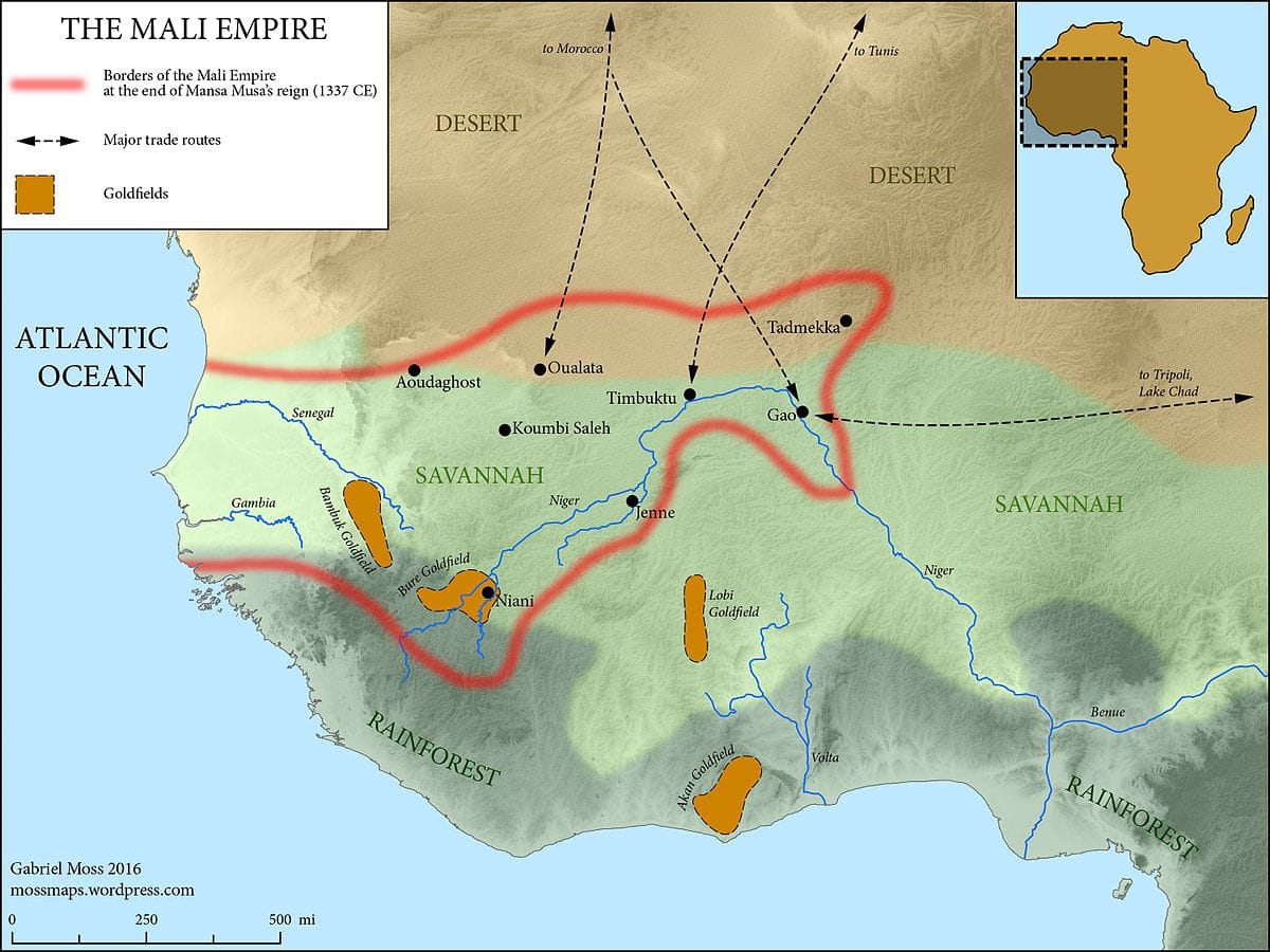
Why was Niani a Strategic Location for a Capital?
Niani’s strategic location on the Sankarani River, a tributary of the mighty Niger River, was central to its success. This prime location provided unparalleled access to the major trade routes that crisscrossed West Africa, making it a hub for the exchange of goods and ideas.
Sundiata Keita, the legendary founder of the Mali Empire, chose Niani as his capital for several strategic reasons:
Trade Dominance: Niani’s location at the crossroads of major trans-Saharan trade routes made it a bustling marketplace, attracting merchants from across the region eager to trade for gold, salt, and other valuable commodities.
Political Control: This central location allowed Sundiata to effectively manage his vast empire, ensuring the flow of goods and information while maintaining political stability.
Agricultural Abundance: The fertile lands surrounding Niani were ideal for agriculture, ensuring a steady food supply for the city’s growing population.
Niani’s leadership invested its wealth in the city, supporting artists, attracting scholars, and constructing impressive buildings. This commitment to cultural and intellectual development transformed Niani into a beacon of civilization, further solidifying its position as a powerful and influential center.
However, some historians suggest that Niani’s reliance on trade also made it vulnerable. Any disruption to these trade routes, whether due to political instability or environmental factors, could have had a devastating impact on the city’s economy.
Where Was the Mali Empire Located?
The Mali Empire flourished in West Africa from the 13th to the 17th centuries, leaving an indelible mark on the region’s history, culture, and language. Centered around the Niger River, the empire’s reach extended across a vast expanse, encompassing present-day Senegal, Gambia, Guinea, Mali, Mauritania, and parts of Burkina Faso and Niger.
Today, the Mali Empire’s legacy is visible in:
Historical sites: Ruins of cities like Niani provide tangible links to the empire’s past.
Cultural traditions: Music, dance, and storytelling practices continue to reflect the empire’s influence.
The Manding language: Spoken by millions across West Africa, Manding originated within the Mali Empire and serves as a testament to its enduring impact.
The Mali Empire’s influence extended beyond its borders, impacting trade, scholarship, and the spread of Islam throughout West Africa. Its legacy continues to shape the region today, reminding us of the power of cultural exchange, economic prowess, and the enduring impact of empires, even after they fade.
Niani Map Location Deep Dive: Outperforming Your Competition
(This section will be completed once the “collection of titles” from competitors is provided. I will analyze the trending keywords and suggest three optimized titles based on that information.)
Conclusion: Niani, a Legacy in Ruins
Niani, once a thriving metropolis and the heart of the Mali Empire, now stands as a humble village in Guinea. Its story reminds us that even the most powerful empires can rise and fall, leaving behind echoes of their existence in the stones, stories, and cultural traditions that endure. As archaeologists continue to explore Niani’s ruins, we gain a deeper understanding of this once-great capital and its enduring legacy on West Africa. Discover the fascinating history behind the Bloody Brook in New Hampshire, a pivotal site in New England’s colonial past. Immerse yourself in the tales of battles fought and the lives lost on this historic battlefield.
Hello, My love for writing is rivaled only by my passion for in-depth research. While many may skim the surface, I dive deep, seeking the hidden gems of information that give a story texture and depth. Every word I write is backed by hours of exploration, ensuring that my work is not just compelling, but also meticulously accurate. Join me on a journey where every piece is a deep dive into the realms of knowledge and storytelling.