Long Island, stretching eastward from New York City, presents a captivating study in geographic diversity. While a simple map reveals its elongated shape, a deeper exploration unveils a complex interplay of regions, each possessing a unique character shaped by its distinct topography, proximity to waterways, and historical development. From the bustling North Shore’s “Gold Coast” to the serene South Shore’s beaches, and the dichotomous East End forks, Long Island’s geography influences its culture, economy, and future. This article delves into these distinct regions, examining their defining characteristics and the implications for various stakeholders. For a broader geographic perspective, check out this 2025 World Map.
Unveiling Long Island’s Regional Diversity: A Geographic Lens
Understanding Long Island requires moving beyond its basic outline on a map. It necessitates examining the nuanced interplay of land and water, the historical narratives woven into its landscapes, and the diverse communities that call it home. Let’s embark on a journey through Long Island’s distinct regions:
The North Shore’s Gold Coast: Cliffs, Mansions, and Maritime Heritage
The North Shore, often referred to as the “Gold Coast,” boasts dramatic cliffs overlooking the Long Island Sound. This region’s undulating terrain, dotted with picturesque villages and opulent estates, reflects its affluent history. The Sound’s influence permeates the North Shore, shaping not only its scenic beauty but also its maritime heritage, fostering industries like fishing, boating, and shipbuilding. The legacy of wealthy industrialists and their grand mansions further contributes to the North Shore’s distinct character, creating a blend of natural splendor and historical grandeur. This unique environment, distinct from the rest of Long Island, offers a glimpse into a bygone era of prosperity and exclusivity.
The South Shore: Beaches, Bays, and a Relaxed Coastal Rhythm
In stark contrast to the North Shore’s dramatic cliffs, the South Shore unfolds with miles of sandy beaches, tranquil bays, and a relaxed coastal atmosphere. The flat terrain provides easy access to the Atlantic Ocean, making it a haven for beachgoers, surfers, and water sports enthusiasts. This accessibility has shaped the South Shore’s identity, fostering a laid-back lifestyle centered around coastal recreation. The barrier islands, protecting the mainland from the ocean’s full force, create a unique ecosystem of bays and inlets, further enriching the biodiversity and recreational opportunities. The South Shore’s gentle topography and connection to the ocean create a welcoming environment that draws visitors seeking respite and recreation.
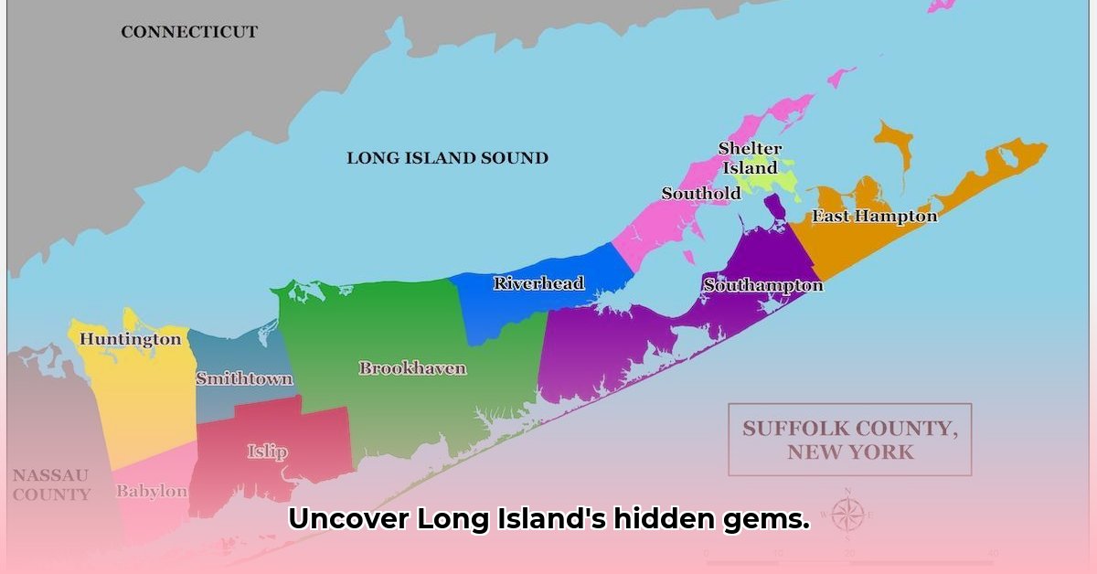
The East End: A Tale of Two Forks – Vineyards, Hamptons, and Rural Charm
The East End, comprising the North and South Forks, presents a captivating duality. The North Fork, celebrated for its vineyards, farm-to-table cuisine, and bucolic landscapes, offers a tranquil retreat from urban life. Its fertile soil and maritime climate create ideal conditions for viticulture, transforming the region into a renowned wine-producing destination. Meanwhile, the South Fork, home to the iconic Hamptons, embodies luxury and exclusivity. The Hamptons’ pristine beaches, high-end boutiques, and celebrity presence attract affluent visitors seeking a glamorous escape. This juxtaposition of rural charm and opulent living defines the East End, offering a spectrum of experiences within a relatively small geographic area.
Long Island’s Geography: Implications for Stakeholders and Sustainable Development
Long Island’s geography is not merely a backdrop; it’s a dynamic force shaping the lives and decisions of various stakeholders. Tourism agencies leverage the island’s diverse landscapes to attract visitors, crafting experiences that cater to a range of interests. Local governments grapple with the challenges of balancing development with preservation, ensuring the sustainability of Long Island’s unique ecosystems. Real estate developers navigate the complexities of land use, considering the environmental impact of their projects. Researchers study the island’s coastal dynamics, seeking solutions to mitigate the effects of climate change and rising sea levels.
Understanding Long Island’s geographic nuances is crucial for informed decision-making. The island’s proximity to New York City has profoundly influenced its development, attracting both residents and businesses. The distribution of population across different regions impacts housing demands, infrastructure needs, and local economies. Recognizing these geographic influences allows for more effective planning and resource allocation. Sustainable development hinges on a deep understanding of Long Island’s delicate ecosystems, promoting practices that protect its natural resources for future generations.
Beyond the Map: Data-Driven Insights for a Deeper Understanding
While a map provides a valuable visual representation of Long Island, it’s only the starting point. Integrating data analysis enriches our understanding, providing a more comprehensive perspective. Population demographics, economic indicators, environmental studies, and historical data contribute to a richer narrative. By combining data analysis with map visualization, we can gain deeper insights into the complex interplay of factors shaping Long Island’s present and future. This data-driven approach empowers stakeholders to make informed decisions, fostering sustainable development and ensuring the long-term well-being of this geographically dynamic island.
Hello, My love for writing is rivaled only by my passion for in-depth research. While many may skim the surface, I dive deep, seeking the hidden gems of information that give a story texture and depth. Every word I write is backed by hours of exploration, ensuring that my work is not just compelling, but also meticulously accurate. Join me on a journey where every piece is a deep dive into the realms of knowledge and storytelling.