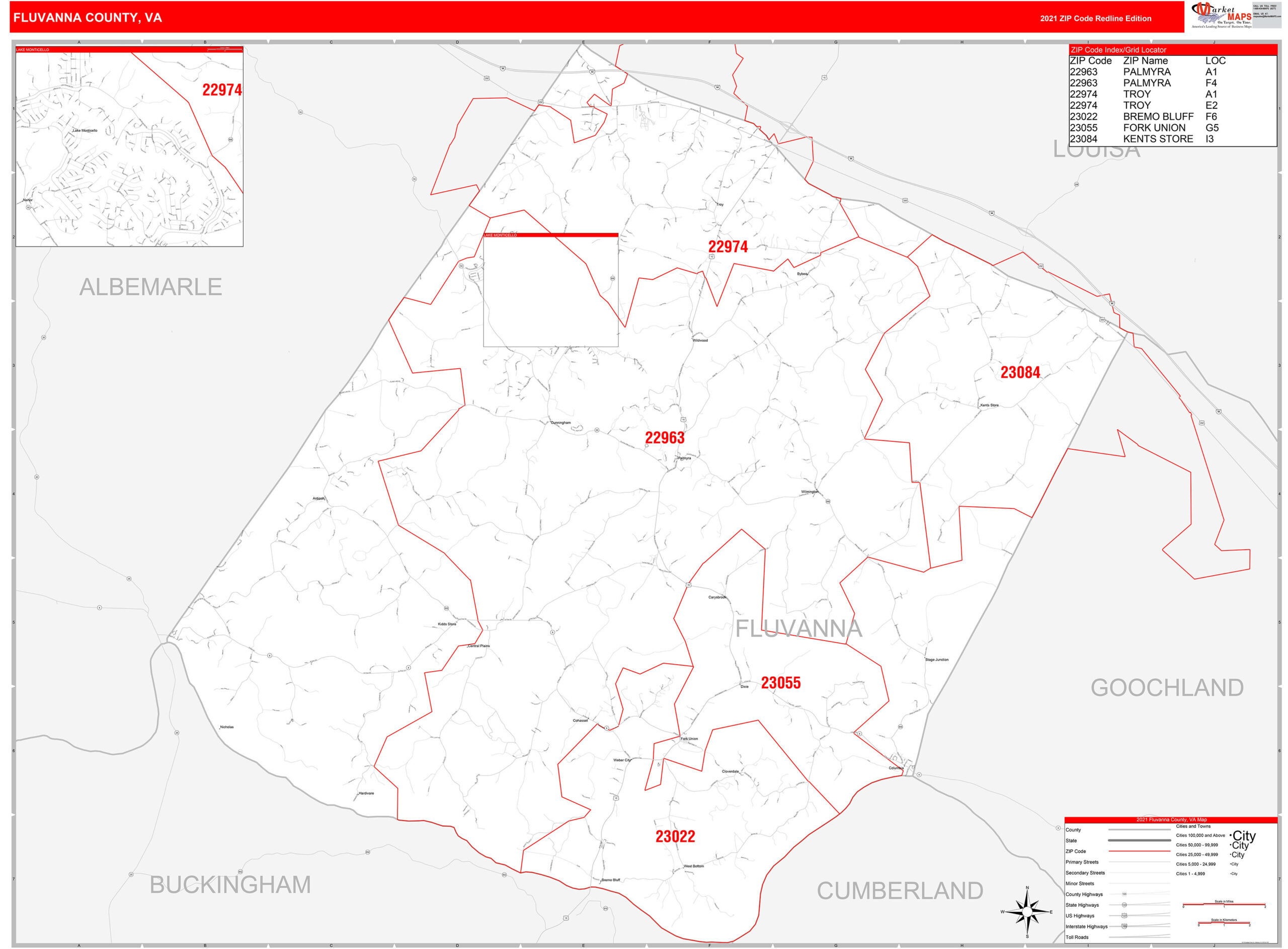
Want to explore Fluvanna County from the comfort of your home? Fluvanna County’s Geographic Information System (GIS) offers a wealth of data, from property lines and zoning to environmental features. This comprehensive guide explains how to navigate these resources, whether you’re a seasoned GIS professional or just starting out. Discover how to use the official county GIS website, explore additional resources, and understand the data’s potential and limitations.
Navigating Fluvanna County’s GIS Landscape
This section provides a roadmap to the various GIS resources available for Fluvanna County, both official and third-party.
Official Fluvanna County GIS Resources
Fluvanna County offers a robust set of GIS resources directly to the public:
- Interactive Online Maps: The official Fluvanna County website (https://www.fluvannacounty.org/planning/page/geographic-informa…) hosts interactive maps with layers for streets, zoning, tax maps, and parcel information. Explore these layers to gain a visual understanding of the county’s layout and specific features.
- WebGIS Data Downloads: For more in-depth analysis, download GIS data directly in ESRI format (.gdb and .shp) through WebGIS (webgis.net/va/fluvanna). This data utilizes the NAD 1983 VA State Plane South (feet) coordinate system, ensuring compatibility with professional GIS software.
- Tax Maps: Downloadable PDF tax maps (numbered 1 through 63) and an index are available on the Commissioner of the Revenue’s website (fluvannacounty.org/cotr/page/fluvanna-county-tax-maps). These maps are particularly useful for property identification and tax assessment research.
- Custom Map Requests: Need a tailored map? Submit a formal request through the online GIS Map Request Form (fluvannacounty.org/planning/page/gis-map-request).
- Planning Department Support: Have questions? The Fluvanna County Planning Department can be reached at (434) 591-1910.
Exploring Third-Party GIS Data Providers
Beyond the official county resources, several third-party websites offer supplementary data:
- Vision Government Solutions (gis.vgsi.com/fluvannacountyva): This site provides detailed property information, including assessments, physical characteristics, and ownership details, updated every two years. You can search by address, owner name, or parcel ID.
- County Office (countyoffice.org/va-fluvanna-county-gis-maps): County Office compiles GIS maps and data from various sources. Remember to verify this information against official county data.
- AcreValue: This platform offers plat maps based on Fluvanna County tax assessor data. It displays property boundaries, landowner information, parcel numbers, and acreage.
While these third-party sites can be valuable, remember that they are not the official source. Always double-check critical information with the official Fluvanna County resources.
A Step-by-Step Tutorial: Using Fluvanna County GIS Resources
This section provides a practical guide to using Fluvanna County’s GIS resources.
Accessing and Utilizing the Official Fluvanna County GIS Portal
- Begin at the Official Portal: Navigate to the official Fluvanna County GIS portal (https://www.fluvannacounty.org/planning/page/geographic-informa…).
- Navigate the Interactive Map: Use the zoom and pan controls to explore the county.
- Explore Data Layers: Activate and deactivate data layers (e.g., streets, parcels, zoning) to customize the map view.
- Uncover Feature Information: Click on map features (like a parcel) to view detailed attributes.
- Utilize the Help Resources: Consult the built-in Help/User Guide for assistance.
Leveraging Third-Party Resources
Explore supplemental websites like lolaapp.com (and others that may exist) for additional visualizations and analysis tools. However, always verify critical information with official Fluvanna County data. Discover the comprehensive resources available through the Itasca County GIS system.
Understanding Fluvanna County GIS: Importance and Applications
Fluvanna County GIS is more than just digital maps. It’s a powerful system for collecting, organizing, and analyzing location-based data. This data encompasses a wide range of information, from streets and addresses to topography, zoning, and emergency services. Uncover the precise location you’re searching for with the Mazzulla Montana zip code details.
Why is Fluvanna County GIS Important?
Access to this spatial data empowers:
- Residents: Make informed decisions about property purchases, understand neighborhood characteristics, and access local services.
- Businesses: Analyze market demographics, identify potential development sites, and optimize logistics.
- Government Officials: Improve planning and development, allocate resources effectively, and enhance emergency response.
Understanding Data Limitations and Future Potential
While Fluvanna County strives for accuracy, the GIS data is primarily for planning purposes, not surveying. Minor discrepancies may exist, so always verify critical information with official sources. Fluvanna County is not liable for issues stemming from data use.
Looking ahead, the field of GIS is continuously evolving. Future developments may include real-time data integration, enhanced accuracy, and improved user interfaces. Ongoing research suggests potential for 3D modeling and other advanced visualization techniques. These advancements could further enhance the power and accessibility of Fluvanna County GIS, offering even more valuable insights into the county’s landscape.
Key Considerations and Disclaimers
- Planning Purposes Only: Fluvanna County GIS maps are not for surveying or legal descriptions.
- Accuracy: While the data is generally reliable, errors can occur. Always verify critical information.
- Liability: Fluvanna County is not liable for damages resulting from the use of its GIS data.
By understanding these guidelines, you can effectively utilize Fluvanna County’s GIS resources to gain valuable insights into this dynamic community.
- China II Review: Delicious Food & Speedy Service - April 17, 2025
- Understand Virginia’s Flag: History & Debate - April 17, 2025
- Explore Long Island’s Map: Unique Regions & Insights - April 17, 2025


