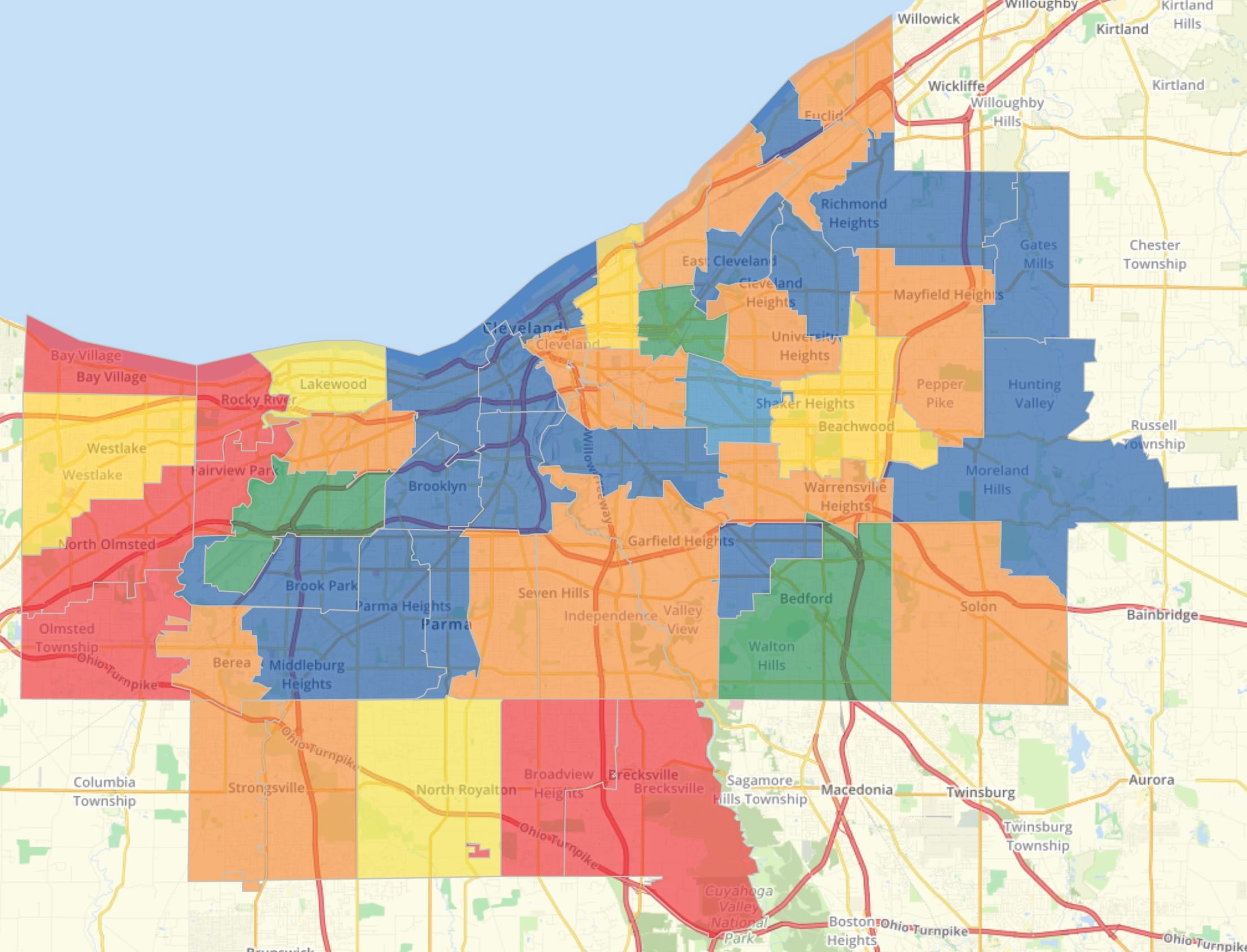
Access Cuyahoga County’s wealth of geospatial data, from parcel maps to fiscal information, through user-friendly online platforms. This comprehensive guide empowers you to navigate the county’s geospatial resources, understand their applications, and unlock valuable insights for personal, professional, or civic purposes.
Discovering Cuyahoga County GIS
What exactly is Cuyahoga County GIS? GIS stands for Geographic Information System. It’s a powerful framework for organizing and presenting location-based data. Imagine a map, but enriched with layers of information—property values, zoning regulations, environmental data, and much more. Cuyahoga County GIS integrates this data, making it accessible and understandable. This system helps residents, businesses, and government make informed decisions, contributing to a smarter, more efficient county.
Accessing GIS Resources
Cuyahoga County provides several avenues for exploring geospatial data:
Cuyahoga County GIS Web Mapping
The primary portal (Cuyahoga County GIS Web Mapping) offers direct access to a vast collection of GIS data and mapping resources, presented “as is.” This is a valuable resource for users comfortable working with raw data.
CuyahogaGIS Hub (Open Data Portal)
The CuyahogaGIS Hub (Open Data Portal) offers a more user-friendly experience. Browse data by category, search by keyword, or even request specific datasets. Think of it as a curated library of information, simplifying the search for what you need.
MyPlace Home
Need specific property information? MyPlace Home provides detailed parcel data. Simply zoom in on the interactive map to access in-depth views. This regularly updated platform ensures you’re working with current information.
ArcGIS Web Applications
Dive deeper into Cuyahoga County GIS data with interactive maps and apps available through ArcGIS Web Applications. Analyze trends, explore different datasets, and create custom visualizations.
Cuyahoga County Fiscal GIS Hub
Cuyahoga County Fiscal GIS Hub offers transparent access to financial data, previously only available in static formats. Explore budgets, expenditures, and other fiscal information visualized through maps and charts.
Practical Applications: Putting GIS to Work
The applications of Cuyahoga County GIS are diverse and impactful:
Property Research
Beyond basic information, delve into historical records, assess property values, and understand the nuances of your neighborhood or potential investments.
Urban Planning
GIS empowers planners to make data-driven decisions. Optimize traffic flow, design effective parks, and plan for sustainable development.
Environmental Analysis
Track pollution levels, monitor green spaces, and develop conservation strategies with precise environmental data.
Emergency Response
In critical situations, GIS can optimize routes for first responders, identify evacuation zones, and enhance disaster relief planning.
Visualizing Data: Making it Clear
Transform raw data into compelling visuals. Cuyahoga County GIS tools facilitate the creation of clear charts, color-coded maps, and infographics. Effective visualization clarifies complex information and engages your audience.
Future of Cuyahoga County GIS
Cuyahoga County is committed to continuous improvement. Future developments may include 3D modeling, real-time data streams, and AI-powered analysis, offering even more powerful insights. Ongoing research suggests that GIS will play an ever-increasing role in shaping the county’s future.
Comparing Cuyahoga County GIS
Benchmarking against neighboring counties like Dorchester County GIS and Edgecombe GIS can reveal areas for improvement and facilitate the sharing of best practices. This continuous evaluation helps Cuyahoga County refine its GIS offerings, ensuring they remain cutting-edge and valuable.
Cuyahoga County: A Closer Look
Located on Lake Erie’s southern shore, Cuyahoga County is a dynamic blend of urban and natural landscapes. The Cuyahoga River, winding through the county, represents both industrial heritage and environmental revitalization. Cleveland, the county seat, pulses with cultural and sporting energy. Surrounding communities contribute to a rich tapestry of traditions and heritage. Cuyahoga Valley National Park offers a nearby natural escape, inviting exploration and recreation. The county’s economy, once dominated by manufacturing, now embraces diverse sectors like healthcare and technology, driven by institutions like Case Western Reserve University and the Cleveland Clinic.
Google My Maps vs. True GIS
While Google My Maps is a useful tool for basic mapping tasks, it differs fundamentally from a true GIS. My Maps is ideal for planning trips or marking points of interest. Full-fledged GIS platforms like ArcGIS and QGIS, however, provide the robust spatial analysis capabilities needed for complex projects like urban planning and environmental management. Key distinctions include data format compatibility, analytical tools, data management features, and visualization options. My Maps shines in its integration with Google’s ecosystem and ease of use, making it a great choice for simple, collaborative map creation. However, for advanced geospatial work, dedicated GIS software remains essential.
Finding Your Parcel Number
Locating your Cuyahoga County parcel number is usually straightforward:
- Check Your Documents: Your deed, tax bill, or appraisal notice likely contains your parcel number.
- Online Property Search: Utilize Cuyahoga County’s online property search, using your address or owner name.
- GIS Web Mapping Application: Pinpoint your property on the County’s interactive GIS map to access its parcel number.
- Plat Maps: Consult plat maps available online or at the County Archives for detailed boundary and parcel information.
- County Offices: If needed, the Cuyahoga County Recorder’s Office or Fiscal Officer can assist you.
Conclusion: Empowering with GIS
Cuyahoga County GIS offers a powerful lens through which to understand and engage with our community. Explore these resources to gain valuable insights, make informed decisions, and contribute to a more connected and informed Cuyahoga County.
- Unlock Elemental 2 Secrets: Actionable Insights Now - April 2, 2025
- Lot’s Wife’s Name: Unveiling the Mystery of Sodom’s Fall - April 2, 2025
- Photocell Sensors: A Complete Guide for Selection and Implementation - April 2, 2025
